
Last checked: November 4, 2026 · Sources: Korea National Park Service, KASI, Seoul Metropolitan Government and Seoul Hiking Tourism Center pages, linked below.
For a first hike to Baegundae, Bukhansan’s highest peak, take the subway and Ui LRT to Bukhansan Ui Station, walk up to the Baegundae Visitor Center, and climb 1.9 km (about 1 hour 30 minutes one way, per the park service). There’s no ticket and no booking.
Trail gates stop letting people in at 17:00 from March to November and at 16:00 from December to February, so start in the morning. The Baegundae routes are open; a landslide has closed the upper part of the Gucheon Valley trail, and national parks close some trails for wildfire season from mid-November to mid-December.
What’s closed right now?
Checked November 4, 2026
- Bukhansan is listed as “partial closure” on the Korea National Park Service (KNPS) live list. The closed part is the upper Gucheon Valley trail, from the Gucheon Falls viewpoint to about 100 m below Daedongmun Gate (1.0 km), shut since a landslide in August 2025. Since October 30, 2026, the lower 0.7 km from the Academy ranger post up to the falls viewpoint is open again, per a KNPS notice of October 29. Entering the closed part can bring a fine of up to 500,000 won.
- The Baegundae summit section reopened on October 2 after repair work.
- The Dobong side of the park (Dobongsan) has all trails open.
- Wildfire season: other parks have announced trail closures from November 15 to December 15, 2026 (Odaesan, Sobaeksan, Gyeryongsan). Bukhansan hadn’t posted its list yet. Check the KNPS live closure list the day before you go.
Walking into a closed section can cost up to 500,000 won under the Natural Parks Act.
Which route should you take?
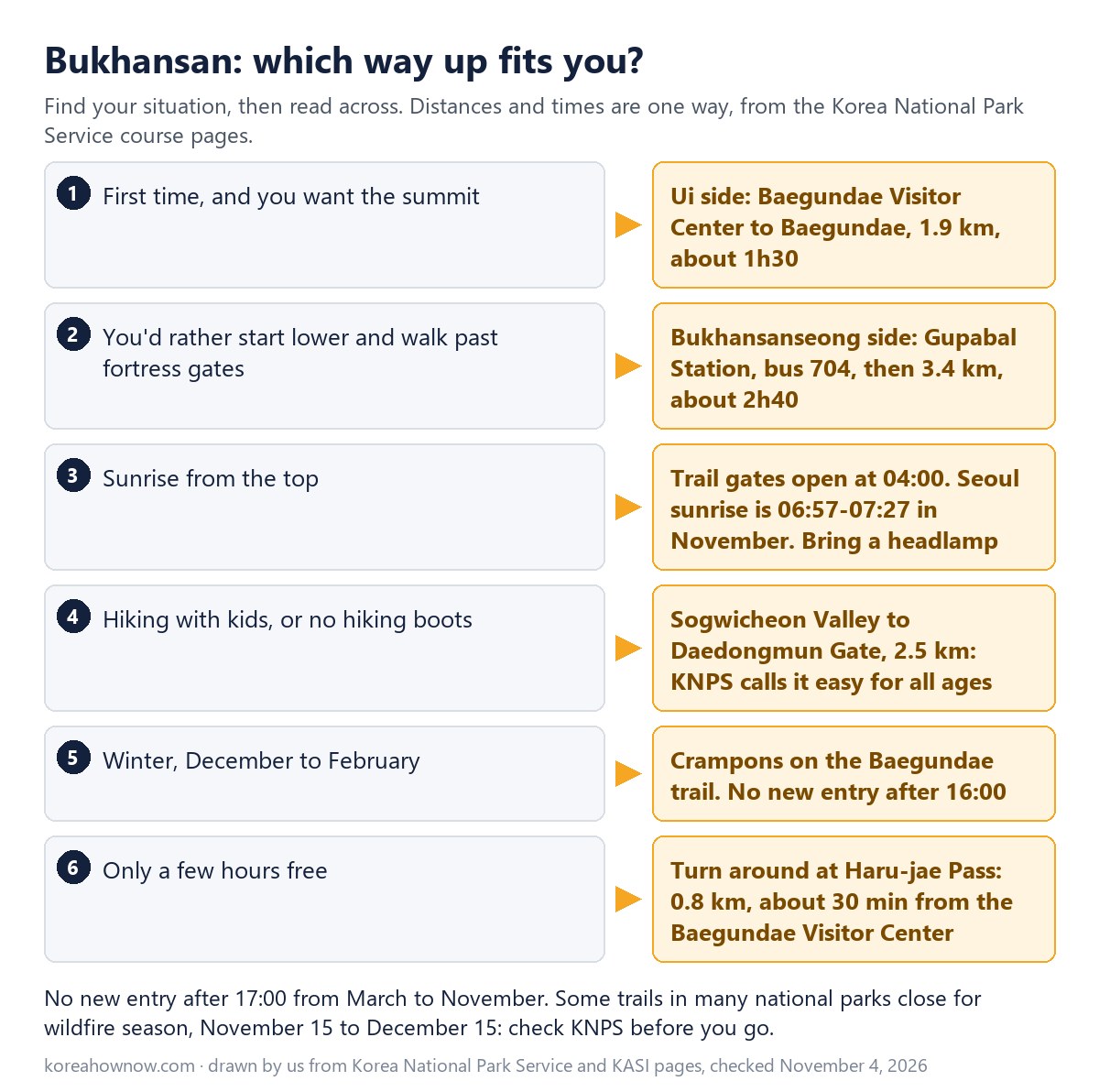
All times below are KNPS’s one-way figures for going up.
| Route | Start | Distance to the top | Time up | Good for |
|---|---|---|---|---|
| Baegundae course (Ui side) | Baegundae Visitor Center | 1.9 km to Baegundae | 1h30 | Shortest way to the summit |
| Bukhansanseong course | Bukhansanseong Visitor Center | 3.4 km to Baegundae | 2h40 | Fortress gates, valley, bus from Gupabal |
| Daenammun course | Bukhansanseong Visitor Center | 5.8 km to Daenammun Gate | 3h | Autumn colors along the fortress, no summit |
| Daedongmun course | Baengnyeon Park ranger post | 2.7 km to Daedongmun Gate | 1h10 | Ridge views of Baegundae without the climb |
| Sogwicheon course | Sogwicheon ranger post (Ui-dong) | 2.5 km to Daedongmun Gate | 1h30 | Easy for all ages, says KNPS |
| Sinseondae course (Dobongsan) | Dobong Visitor Center | 3.3 km to Sinseondae | 1h40 | A different granite peak in the same park |
Our pick for a first visit is the Ui side. It’s the shortest climb, and the Seoul Hiking Tourism Center near the station rents boots and poles. Pick the Bukhansanseong side if you’d rather walk a gentler valley first and don’t mind about 40 minutes more each way.
How steep is the Baegundae trail?
KNPS splits the Ui-side climb into three parts:
| Section | Distance | Time |
|---|---|---|
| Baegundae Visitor Center to Haru-jae Pass | 0.8 km | 30 min |
| Haru-jae Pass to Baegundae Shelter | 0.6 km | 40 min |
| Baegundae Shelter to the summit | 0.5 km | 20 min |
The first part mixes dirt and rock. After Haru-jae you climb stone steps with wire ropes and wooden stairs on the hard bits. The last 0.5 km is the steepest: a narrow rock path with fixed wire ropes. KNPS advises hiking boots and poles, and a good rest at the shelter before the final push.
On weekends the summit section gets crowded, and KNPS warns that the queue can slow you down a lot. Areas off the marked trail near Baegundae are closed because of the fall risk.
How do you get to the trailhead from central Seoul?
Ui side (Baegundae course)
- Ride the subway to Sinseol-dong (Lines 1 and 2) or Sungshin Women’s University (Line 4), then change to the Ui LRT. From Hongdae, take Line 2 to Dongdaemun History & Culture Park and change to Line 4 for Sungshin Women’s University, or change at Seongsu to the Line 2 branch train for Sinseol-dong.
- Ride the Ui LRT to the last stop, Bukhansan Ui Station.
- Walk up the road past Doseonsa Temple to the Baegundae Visitor Center. KNPS gives 2.0 km and about 30 minutes from its Ui ranger station, mostly on asphalt with a wooden boardwalk near the top.
KNPS’s own directions use Line 4 to Suyu Station, then city bus 120 from the Gangbuk-gu Office stop to the Ui-dong terminus. Pay with a T-money card and you get the transfer discount between the subway, the LRT and the bus. Fares are in our Seoul subway fares and transfers guide.
Bukhansanseong side
- Take Line 3 to Gupabal Station.
- Take bus 704 (or Yangju bus 37) from the Gupabal Station Exit 2 stop (12111) to Bukhansanseong Entrance Intersection (북한산성입구교차로, stop 12233). KNPS calls this stop 북한산성입구.
- Walk to the Bukhansanseong Visitor Center, where the trail starts.
There’s no entrance fee for the park. KNPS’s Bukhansan fee page lists only parking and campsite charges.
What time do the trails close?
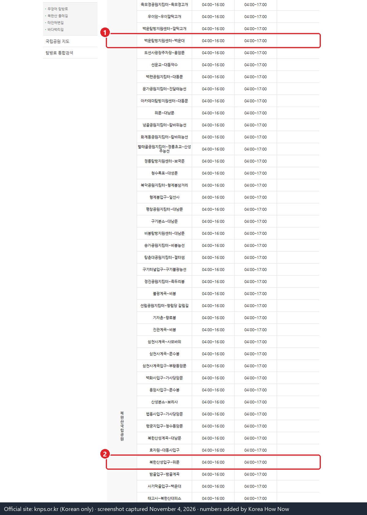
Every Bukhansan trail entry point, including the two Baegundae routes, runs on fixed hours:
| Months | Gates open | No new entry after |
|---|---|---|
| March to November | 04:00 | 17:00 |
| December to February | 04:00 | 16:00 |
The cut-off is the last time you can start up, not the time you must be down. Sunset is the real limit in late autumn.
| Date (Seoul) | Sunrise | Sunset |
|---|---|---|
| November 1 | 06:57 | 17:34 |
| November 15 | 07:11 | 17:22 |
| November 30 | 07:27 | 17:14 |
| December 15 | 07:39 | 17:15 |
When should you start on a November day?
Here’s our timing for Sunday, November 15, 2026, with sunset at 17:22. KNPS publishes uphill times only, so we assume the way down takes as long as the way up.
| Leg (Ui side) | Time |
|---|---|
| Ui ranger station to Baegundae Visitor Center (road) | 30 min |
| Visitor Center to summit | 1h30 |
| Rest and photos at the top | 30 min |
| Summit back to the Visitor Center | 1h30 |
| Visitor Center back down the road | 30 min |
| Total | 4h30 |
To be back on the road by sunset, you’d leave the Ui ranger station by 12:50 at the very latest. We’d aim for 10:00 on a weekend: KNPS warns the summit queue can hold you up a lot, and you don’t want the wire-rope section in the dark.
On the Bukhansanseong side, the same sum is 2h40 up, 30 minutes at the top and 2h40 down: about 5h50. That means 11:30 at the latest from the Bukhansanseong Visitor Center; we’d start by 09:30.
The Seoul Hiking Tourism Center’s own loop from its Ui-dong office to Baegundae and back (9.98 km) lists about 4h20, close to our figure.
Do you need special gear, and can you rent it?
KNPS says to wear hiking boots and use poles on Baegundae. In winter many sections ice over, and KNPS says crampons (아이젠, “aijen”) must be worn.
The Seoul Hiking Tourism Center (Bukhansan Center) is about 5 minutes on foot from Bukhansan Ui Station Exit 2, on the 5th floor of 52 Samyang-ro 173-gil. It rents backpacks, hiking shoes, tops and pants, gloves and poles to foreign visitors, and it has lockers and a changing room.
It opens 09:00 to 18:00 and closes on Mondays, January 1, and the Seollal and Chuseok holidays. Prices aren’t on the official site; you book through its link at seoulhiking.or.kr. Phone: 1533-2608.
The center opens at 09:00, so it suits a mid-morning start, not a sunrise hike.
Can you hike Bukhansan for sunrise?
Yes, the trail gates open at 04:00 all year. Seoul’s sunrise in November runs from 06:57 to 07:27, so you’d start in full darkness. Bring a headlamp and allow extra time on the wire-rope section.
What if something goes wrong on the mountain?
Call 119 for rescue. Bukhansan National Park’s office line is 02-909-0497 (the Dobong office is 031-828-8000). For help in English with a call or a sign, the 1330 Korea Travel Hotline can interpret.
Smoking outside designated spots in a national park can bring a fine of up to 2,000,000 won, and so can carrying lighters or other flammables into areas the park designates. Stay on marked trails. If you’re coming for the leaves, Bukhansan isn’t on the official foliage forecast map; see our fall foliage 2026 guide for the nearest Seoul reading.
Read next
Sources
- Korea National Park Service, Bukhansan National Park: courses, transport and fees (Korean), checked Nov 4, 2026
- Korea National Park Service, Trail entry hours by trail (입산시간지정제, Korean), checked Nov 4, 2026
- Korea National Park Service, Live trail closure list (Korean), checked Nov 4, 2026
- Korea National Park Service, Bukhansan: Gucheon Valley landslide closure detail (Korean), checked Nov 4, 2026
- Korea National Park Service, Bukhansan notices (Korean), checked Nov 4, 2026
- Korea National Park Service, Baegunbongammun to Baegundae summit reopened, Oct 1, 2026 (Korean), checked Nov 4, 2026
- Korea National Park Service, Odaesan autumn wildfire trail closures 2026 (Korean), checked Nov 4, 2026
- Korea Policy Briefing, 2025 autumn wildfire season and national park trail closures (Korean), checked Nov 4, 2026
- Korea Astronomy and Space Science Institute, Sunrise and sunset by city (Korean), checked Nov 4, 2026
- Seoul Metropolitan Government, Ui LRT opening: stations and transfers (Korean), checked Nov 4, 2026
- Seoul Hiking Tourism Center, Centers, hours and gear rental, checked Nov 4, 2026
- Seoul Hiking Tourism Center, Bukhansan Center leaflet (PDF), checked Nov 4, 2026